
American River North Middle South Forks California
American River North Middle South Forks, 4-20 days, March - November
The infamous Giant Gap is a mind numbing, spine jolting, full on floodgate level rush through a full 14+ miles of expert level whitewater rafting. It is actually part of the North Fork American River which many see as one of America's great whitewater challenges. Do NOT come here and do this river unless you are without question a top level white water specialist. The camping in this area tends to be quite rugged. If for some reason you do not sleep in your Vanabode you will find many parts of the forest to be very rocky and difficult to pitch a tent on or make a comfortable sleeping bag spot.
The American River region contains 100's of square miles of hiking trails for both foot traffic as well as offroad mountain biking. You can also ride your bike on the roads for many miles along the river. The bridges make a fun place to take pictures and take breather for both hiker and biker. As mentioned you can conduct an expert level, life threatening white water rafting trip, cruise through in your vehicle, bike, fish with license, hiking, and camp. Limited boating can be done on various portions of the river. I have never done it but fly-fishing is popular in the calmer smaller streams. You can also catch steelhead in the lower part of the river where it flows into Sacramento.
There are lots of old mining trails, rootings and even some run down old buildings from back when they were digging gold out of this area. The rocky nearly unclimbable mountain cliffs rise at least 1,800 feet around and above the river below which makes for spectacular photographic opportunities as well as shear beautiful romantic scenery.
Lover's Leap picnic area is very picturesque as long as you don't mind the good possibility you will have company. You can get close to what many believe to be the oldest black oak tree in California at over 350 years old.
BLM Park officials have added a super cool day trip type hiking trail called Cronan Ranch for those not interested in long overnight runs.
|
There is plentiful hiking trails all throughout the region with some of the best trailheads starting or ending right on the water. The trails in the North area are the most difficult. Directions: Drive U.S. 50 to Placerville California. Take Highway 49 to Highway 193 where you will start at the Chili Bar Reservoir, a dammed up man made lake type body of water. |
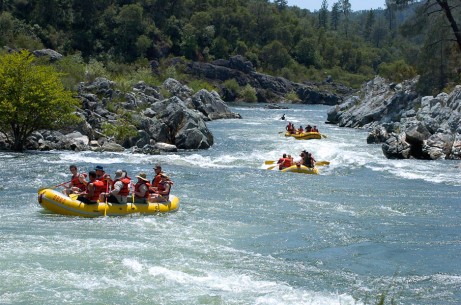 |
Vanabode Special Notes: Find a portion of the river that is calm and play in the water some. Otherwise the long hikes will keep you breathing hard and sweating. I wouldn't get on the rafting portions of this big white water unless you are a very experienced rafter, with proper safety and boating gear, and a good swimmer. Do not let kids in the water without a life jacket on at the American River North Middle South Forks in California.
![]()
![]()
![]()
List All Vanabode Pages
List All Destination Pages
How will this book help Me?
Links
Affiliates
Contact us, Get Help
![]()

Home Contact Us Copyright © 2007-2017 Privacy Policy Terms and Conditions Media Press Affiliate